Tool Search: Address Information
The Address Info tab lists information about the selected address. The address provides a location for the household, and ties the students to the address. Addresses are listed on several reports, reviewed as part of the Enrollment processes and several other areas of Infinite Campus.
Districts can choose to work with their city's planning committee or utility company to import all district addresses.
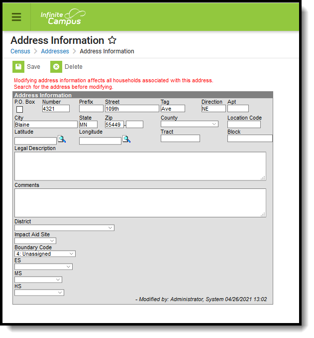 Address Information
See the Address Information Tool RIghts article for information about rights needed to use this tool.
The Address Information tool is displayed when searching for Households and selecting the Address item from the Household Search Results or by searching for Addresses and selecting a search result.
Addresses can be added to Campus from the Address Info tab, but it is recommended that the Add Address wizard is used to add multiple addresses to Campus.
Address Info Definitions
The following table defines the fields available on the Address Info tab. Some fields on this editor are localized by states or district, and may not appear.
Field | Definition |
|---|---|
Post Office Box | Indicates the address is not a physical location but a mailing location. |
Number | House Number of the address, or Box number if the address is a P.O. Box address. |
Prefix | A one-character compass point preceding a street name that indicates a direction - N, S, E, W. |
Street | Name of the street. Only the street name is entered into this field. Labels like Avenue, Road, Drive, etc. are considered an Address Tab. |
Tag | Label of the entered street - Avenue, Street, Blvd., etc. |
Direction | Direction indicating the placement of the street within the city limits. |
Apt | Apartment number if this address is for an apartment building location. |
City | Postal city for the address. |
State | Two-digit state code for the address. |
Zip Code | Postal zip code (plus 4 if available). |
County | County in which the address is located. |
Other Address Fields | |
| Location Code | Numeric representation number to accurately locate the address. |
| Latitude | Numeric representation of the address based on north and south placement, generally imported from a district GIS application. Use the magnifying glass to locate the latitude of the address. The house number and street name must be populated in order to populate the address latitude. It is also recommended that one or all of the following also be entered:
This field allows for a 10-digit number - 4 digits before the decimal point, 6 digits after the decimal point. The total Geocode value may be up to 14 digits, but only 10 digits saves. If an error message displays, verify the entered values for the address are correct. You may need to change the street name or add a direction. For example, Lexington Ave may need to be entered as County Road 17. |
| Longitude | Numeric representation of the address based on east and west placement, generally imported from a district GIS application. Use the magnifying glass to locate the longitude of the address by clicking the icon next to the Longitude field. The house number and street name must be populated in order to populate the address longitude. It is also recommended that one or all of the following also be entered:
This field allows for a 10-digit number - 4 digits before the decimal point, 6 digits after the decimal point. The total Geocode value may be up to 14 digits, but only 10 digits saves. If an error message displays, verify the entered values for the address are correct. You may need to change the street name or add a direction. For example, Lexington Ave may need to be entered as County Road 17. |
| Tract | A small, relatively permanent statistical subdivision of a county, averaging about 4,000 inhabitants, depicted with a unique numeric code within each county. Used by the US Census Bureau to compare data from decade to decade. |
| Block | The smallest statistical area used in the US Census Bureau’s data collection, depicted with a four-digit number. Multiple blocks can exist within a Tract. |
| Legal Description | Provides a definition of the address used in Impact Aid reporting when a street location is not available. Each county determines what a legal description is (lot and block data). This field only shows when the Impact Aid System Preference is turned on. See the Impact Aid section for more information. |
| Comments | Provides any additional notes on the address and are for internal reference only. |
| District | Indicates the school district to which students at the address attend. This is often used in school choice settings. |
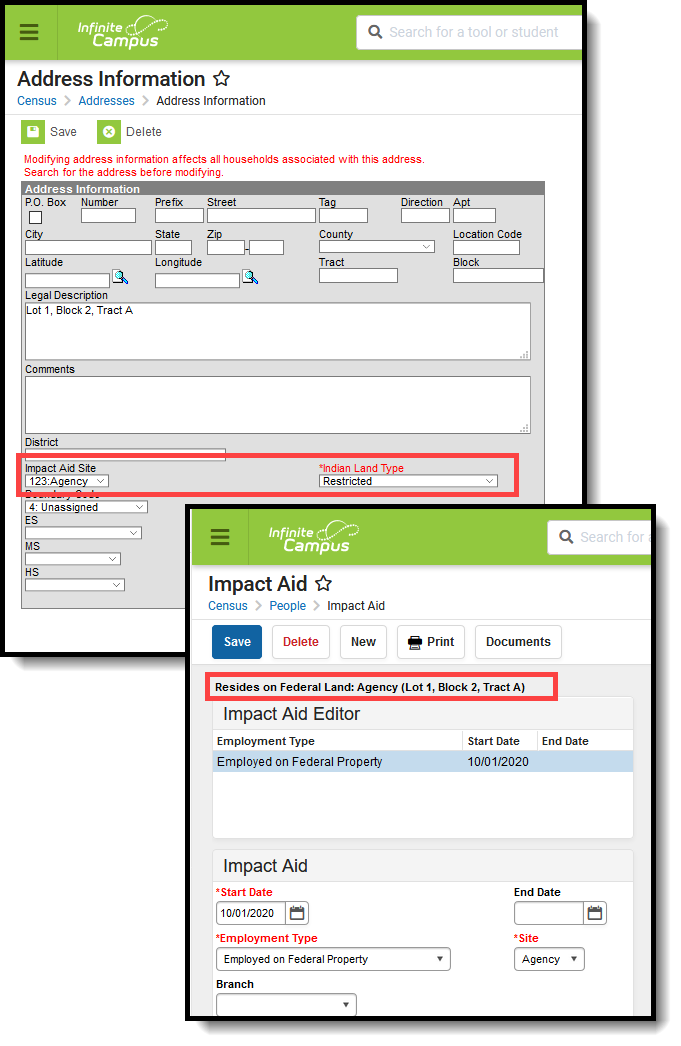
| Impact Aid Site | Lists any Impact Aid Site associated with the address. When this field is populated, the Impact Aid tool displays the address is part of federal land. See the Impact Aid section for more information. |
Edit Address Information
- Select the appropriate address from the SearchResults.
- Enter data into the appropriate fields.
- Select the District in which the address is located from the dropdown list. This helps with planning and busing.
- If the address is considered part of federal land, select the Impact Aid Site from the dropdown list.
- Click the Save icon when finished.
Modification Alerts
Because address information is sensitive data, tool rights to modify and view address information should be closely monitored. In addition to tool rights, visual notification is displayed on the Address Info tab when changes are made to the address. This appears at the bottom of the Address Information editor and notes who made the modification and when.
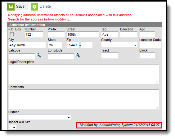 Address Modification Notice
Impact Aid
Impact Aid funding is designed to assist local education agencies that are affected by federal activities in their school districts (like reservation land or military bases). For more information on the Impact Aid program, see the Office of Impact Aid website.
Impact Aid Workflow
Follow these steps to track Impact Aid information in Campus.
Done | Task |
|---|---|
| Create Impact Aid Sites. |
| Turn on the System Preference for tracking Federal Impact Aid. |
| Assign Impact Aid Sites to household guardians on the Impact Aid tab. |
| Assign Impact Aid Sites to Addresses within the district. |
| Generate the Impact Aid Site Report to find students who live on Federal installations. |
| Generate the Impact Aid Employment Report to find guardians who are employed by the government. |
Impact Aid Address Fields
As stated above, each county determines what the legal description is for a housing unit when a physical address of that unit is not available or does not exist. An example of a legal description would be the following:
- Lot 1, Block 2, Tract A
- NE 1/4, Section 12, T1N, T2W
It is assumed that a housing unit that uses the legal description does not necessarily have a P.O. Box as a mailing address.
An address can be added using the Add Address tool that does not contain standard address fields (number, street, tab, etc.). When an address is saved without this information, it cannot be searched in Campus. When a legal description is used in place of an address (when a household does not have an address), the legal description is searchable, and returns in the search results in the following areas:
The Legal Description is also included in the Person Summary Report.
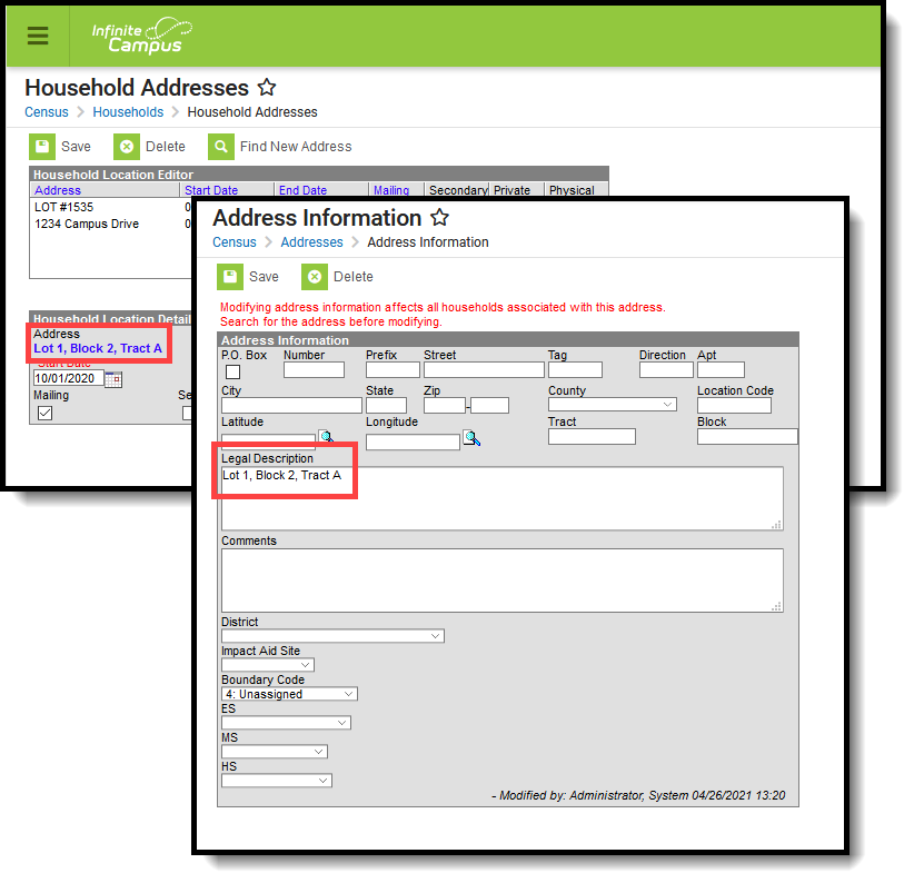 Address - Legal Description
Impact Aid Address Information
When a person's household address is part of an Impact Aid Site (the Impact Aid Site and Indian Land Type fields are populated on the Address Info tab), a message displays at the top of the Impact Aid tab.
 Address Display on Impact Aid Tool
